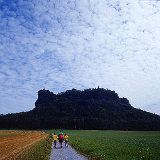
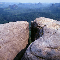
| On the trail to Tablemountain Lilienstein |
 |
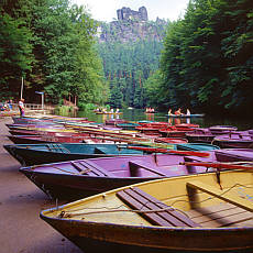
| On Lake Amsel |
 |
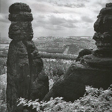
| Brosin needle |
 |
| Felsformation am Kuhstall |
 |
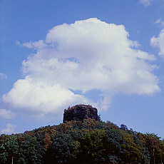
| Pavillon |
 |
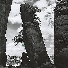
| Climbing rock needle Babarine |
 |
| Zirkelstein |
 |
| The Elbsandstone Mountains - also known as Saechsische Schweiz - is a true hicking paradise. A wide range from easy walking for families with small children upto challenging climbing tours - all is possible. |
Lilienstein - The King of the Table Mountains
- Start of the hiking tour in Koenigstein (pure walkingtime ca 2 1/2 hours)
- Ferry over with the current ferry boat over the river Elbe to Halbestadt
- In comfortable serpentines we walk up to the highplateau Ebenheit

| |
- Crossing the highplateau Ebenheit on the trail to Tablemountain Lilienstein
- Using a save stairway called "Steiganlage" we reach the Lilienstein summit
(the stairway consists of ironsteps with handrail and is savely walkable for children as well)
Sensational lookout, like out of an airplane window downto the winding Elb river and the citadel Koenigstein
- Rest at mountain inn Lilienstein with beer garden
- Descent along the north stairway downto the church trail, Lottersteig and Kottesteig to spa town Rathen
- As finale of the walking tour a good idea may be a rowing boat trip on the near lake Amsel , over whom the Locomotive (a monumental rock formation) is enthroned
- Cruise with the paddle wheel steamer back to Königstein
 GPS-Track circular route Lilienstone Table mountain, Rathen, lake Amsel (15 km) GPS-Track circular route Lilienstone Table mountain, Rathen, lake Amsel (15 km)
 Upload theLilienstein Rathen roundtour as Track direct into your Garmin GPS Upload theLilienstein Rathen roundtour as Track direct into your Garmin GPS |
 |
 |
Schrammstein lookout
- Cruising with ship from Bad Schandau upstream to Schmilka
- Following the Wurzel path through the Heringsground to the Holy Stiege, a comfortable stairway
- Follow the trail Schrammsteinweg on mountain top, it leads in steady elevation to the Schrammstein lookout
- Descent along the front Promenade to the Schramm gate
- Over the Obrigensteig trail we come to Postelwitz
- Passing the Siebenbuerger houses in Postelwitz leads back to the starting point of the daytour in Bad Schandau
Hikingmap Schrammstone region
GPS-Track hiking Schrammstein lookout (16,4 km) |
|
Upper Affenstein trail
- Driving with car or the Kirnitzsch tramway towards Lichtenhainer Waterfall
- Near Beuthenfall is the starting point for walking tour to Dietrichsground, Blossstock and lower Affenstein trail
- Through the Wild Hell climbing up to the Upper Affenstein trail (easy),
alternativ den Klettersteig (Zwillingstiege) durch das Grosse Bauernloch (extrem difficult, partly only u-iron as climbing facilities available, therefore head for heights absolutely required :o))
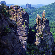
- The view from upper Affenstein trail to the Brosin needle is unique and breathtaking.
- After Surrounding the Affenstein massif on the panorama trail we make a side trip on the long Horn to the highest viewpoint (590 m)
- From long Horn we walk back towards Frienstein (front side Raubschloss)
- On the Koenigs trail or Heide trail we come back to the starting point
Hiking map Affenstein region
GPS-Track hiking upper Affenstein trail (8,6 km) |
 |
Kuhstall (cowhouse), small/big Winter Mountain
- Start of the daytour in Bad Schandau, travel with the nostalgic tramway to Lichtenhainer Waterfall
- Walking to Kuhstall (cowhouse)
- Over the foreigner trail to the small Winter Mountain
- Climbing up to Pavillon
- Walking along the Reitsteig trail to the Big Winter Mountain
- Descent to Schmilka with side trip to the Kipphorn lookout
- With the ship we go back to the starting point in Bad Schandau
|
Climbing in Biela valley
- Starting point Ottomill
- Closeup watching the climbers in action
- Walking tour to Grenzplatte
|
 |
 |
Imperial crown and Zirkelstone Mountains
- Driving from Bad Schandau above Reinhardtsdorf to Schoena
- Over the stairway with iron steps and iron handrail (attention at thunderstorm) we reach the summit of the Zirkelstone Table Mountain,
The Lookout is fabulous
|
Prebisch gate
Due to the outstanding build and signed trails hiking in the Elbsandstone Mountains is a pleasure.
Stairways, ladders and miscellaneous climbing facilities enable the walking over dangerous locations without climbing experience, climbing KnowHow and safety ropes.
So for the walkers and hikers is opened up a fantastic alpine world, which is everywhere in the world reserved for the professional climber.
Weatherforcast:
© made4you


